|
Dhanbad
The district can be divided into three broad natural divisions,
viz., (I) the north and north western portions consisting of the
hilly region, (ii) the uplands containing coal mines and most of
the industries and (iii) the remaining uplands and plains lying
to the south of the Damodar river consisting of cultivable flat
lands . The north and north western division is separated for the
entire length by the Grand trunk road.
In the western middle part of the district are the Dhangi hills,
situated in the strip falling between the Grand trunk road in the
north and the Grand chord line of the Eastern Rly. In the south,
these hills extend from Pradhankhanta to Govindpur, reaching a maximum
altitude of 1,256 feet at Dhangi. Further north, a branch of the
Parasnath hill runs through Topchanchi and Tundi, the highest point
of 1,500 feet being reached at Lalki. The southern part of the district
is largely comprised of undulating land. The general slope is from
west to east, the direction followed by the two major rivers, Damodar
and Barakar.
Dhanbad is one of the most important industrial centres in India.
In and around Dhanbad is the richest mineral wealth of India.
Excursion
Topchanchi
The village is the headquarters of the development block being the
same name. It is situated on the Grand Trunk Road. The Parasnath
Hill is located nearby. The Topchanchi Water Reservoir spreads over
an area of 214 Ac. It is a noted picnic spot.
Topchanchi Lake (Dhanbad)
The Topchanchi Lake, which lies 37 km from Dhandbad, is an artificial
lake surrounded by green hills and forests. It makes a wonderful
picnic spot.
Charak Pathar
The village is situated in GOVINDPUR development block. It is a
very large ancient boulder of white stone. It derives its name from
this stone.
Chati Gobindpur
The village which also is located in GOVINDPUR development block,
contains two ancient pillars which are locally associated with Emperor
Asoka and the Afghan Chief Sher Shah.
Gopalpur
The village lies in Nirsa-cum-Chirkunda development block. It contains
an ancient pillar said to date back to the time of Emperor Asoka.
There is also a large stone image said to be of Asoka himself.
Jhinjhipahari
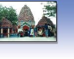
The village is situated in Baghmara development block . It is said
that an ancient temple of Lord Shiva was found when the mines here
were being worked.
Meva
The village is situated in Nirsa-cum-Chirkunda Block . It contains
ancient pillars said to date back to the time of Emperor Ashoka.
There is also a large stone image said to be of Ashoka himself.
Panrra
The village which also lies in Nirsa-cum-Chirkunda Block, it said
to have derived its name from the Pandavas. According to local legend
the Pandavas spent some period of their exile in hiding at this
place. The village contains an ancient temple of Lord Shiva known
as Pandeweshar Mahadev. The temple is believed to have been constructed
by Hindu King at a much later day.
Chark - Khurd
The village, situated about 10 Kms from Tundi on the Dhanbad- Govindpur
-Giridih Road, is noted for its hot spring .
Maithon
It is census town situated about 48 Kms. From Dhanbad and 5 Kms.
From Kumardubhi Rly. Station . The Maithon Dam and Hydel Power Stations
are located in this town.
Panchet
This is also a census town situated 9 Kms. South of Chirkunda and
about 54 Kms. South east of Dhanbad. The Panchet Dam, around which
the Township has developed, is located here.
Jamadoba
There is a water filter plant of M.A.D.A (Mineral Area Development
Authority ) from where water supply is being made to Dhanbad District.
Central Mining Research Station
Central Fuel Reaserch Institute
Directorate General of Mines Safety
Top
Getting There
By Air
Dhanbad was connected by Vayudoot Service with Patna and Ranchi
which in turn connected by Indian Airlines services with Calcutta
and Delhi.
By Rail
Dhanbad has an important railway station on Eastern Railway and
is very well connected with Patna,Calcutta and other important Cities
in India.
By Road
Dhanbad is very well connected by roads with important towns in
Jharkhand.
Top
Weather
Temperature (deg C)
Summer Max- 44, Min- 22;
Winter Max.-22, Min- 8.
Rainfall : 1418 mms (July to September).
Best Season : October to March.
Clothings
Summer - Cotton / Tropical;
Winter - Light Woollen.
Top
General Information & Accomdation info on Dhanbad city of Jharkhand - India
|