|
Malkangiri
The district is named after its headquarters town Malkangiri .During
formation of Orissa Province in 1936 Malkangiri was a "Taluk"
of Nabrangpur sub-division of Koraput District of Orissa.In 1962
it was upgraded to a subdivision of Koraput District.The present
Malkangiri got its identity as an independent district due to reorganisation
of districts of Orissa as per notification on 1st October,1992 with
effect from 2nd October 1992, an area of 5,791 sq.kms and lies between
17° 45'N to 18° 40'N latitudes and 81° 10'E to 82°E
longitude.Oriya is the main spoken language.
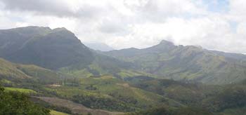
The district is divided into two distinct physical divisions.The
eastern part is covered with steep Ghats,Platues,Valleys sparsely
inhabited by primitive tribes notable among whom are Bondas,Koyas,Porajas
and Didayis.The rest of the district is comparatively flat plain
broken by a number of rocky wooded hills.Almost the whole of the
district is a vast dense jungle. Potteru,Saberi,Sileru,Kolab and
Machhakunda are the main rivers flowing in the district.
Excursion
Balimela
Balimela is a block in Malkangiri District, which is 35 kms. from
the east of Malkangiri. A Hydero-electric Project has been established
near about the Town jointly by the Government of Orissa and Andhra
Pradesh. A dam is being constructed at Chitrakonda, 25 kms. from
Balimela across the river Sileru and the reservoir would submerge
a rich forest area of the District. The total inflow into the reservoir
is shared equally by the two Governments. The share of the Andhara
Pradesh Government is flow downstream the river while that of Orissa
Government is diverted to a high-head power some 15 kms. south of
Balimela. It is estimated that the power-house is generating 240,000
KW at 60% load factor. The tail water is subsequently utilised for
irrigation about 2.4 lakh acres of land in Malkangiri and Motu plains.
Bonda Hills
Bonda Hill comes under the Khoirputput Block of Malkangiri District.
This is the living place of Bondas,the primitive tribal community
in Malkangiri District. It is surrounded on all sides by dense hilly
forest. The Bondas of the place even now remain nacked, and it is
believed that they were cursed by Godess Sita, as they laughed at
her while she was bathing in a kunda which is named as Sita Kunda
at Bonda Hill. There is one specific festival called "Patkhanda
Yatra" at Mudulipada which is celebrated by them in the month
of January by the Bondas in which they worship a sword. They believe
that this sword is belongs to Pandavas. Apart from these things
many more to be seen on the Bonda Hill.
Ammakunda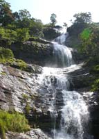
Ammakunda is one of the tourist places in Malkangiri District. It
is situated at Khoirput Block near about 70 Kms. from the District
Headquarter.This cool place embraces a natural water fall and subsequent
flow of water forming a narrow gorge. The fishes found in that gorge
are quite friendly to the human being and are believed to be the
form of Lord Vishnu in " Matsya Avatar". Fishing in that
place is not practised according to this belief of the local people
of Malkangiri as well as the visitors. Visitors can enjoy their
stay at this place by feeding the fishes. This area is surrounded
by dense forest and small hillocks.
Motu
Motu is the southernmost point of the Malkangiri District situated
at 150 feet from the see level at the confluence of the rivers Sabari
and Sileru.Timbers and bamboos are transported in large quantity
from this place down the Sabari and Godavari to Rajahmundary. This
Tahasil Headquarter attracts the tourists for it's beautiful "Jagannath
Temple" and "Moogi Point"- the extreme south point
on the bank of the confluence of the river Savari and Sileru. Difference
in colour of the water of these two rivers can be marked even after
confluence. A statue of "Utkal Gourav Madhusudan Das"
is built inside the park near the confluence.
Satiguda Dam
Satiguda Dam is situated at a distance of 8 Kms. from Malkangiri
Town. The Reservoir provides irrigation facility to the near by
cultivable land throughout the year. The natural beauty of the Dam
can be enjoyed in the early morning and evening hours. Boating facility
is also available inside the Reservoir, which attracts visitors
as well as the local people. Lord Shiva is being worshiped inside
a cave near the Dam. Being surrounded by a large number of small
hills this place is considered to be the most favourite picnic spot
of the people. A guest house of Irrigation Department of Government
of Orissa is built which provides accommodation to the official
VIPs.
Manyamkonda
Manyamkonda is one of the GPs of Kalimela Block and it is situated
at about a distance of 90 Kms. from the District Headquarter. This
is an important religious place in Malkangiri District as the famous
God of the Malkangiri District (Lord Mahaprabhu) is being worshiped
at this place.Every year during the month of March/April a festival
is being celeberated here.Every alternate year the famous festival
known as "Bada Yatra" of Malkangiri starts from this place
to Malkangiri "Mauli Maa Temple". Three Gods namely "Kanam
Raju" relates to Lord Krishna,"Pota Raju" relates
to Vima and "Bal Raju" relates to Arjun are being worshiped
in this festival.This place is surrounded by number of small hills.
Thel scenic beauty of this place and the temple of the Lord Mahaprabhu
arrtacts a large number of religious visitors to this place.
Hill Temples
Bhairavi Temple is situated at a distance of 3 Kms. from the Malkangiri
Town.The hill diety of Malkangiri is worshiped by the people coming
from Jeypore and People leaving Malkangiri for their safe journey.A
number of religious visitors are attracted to this temple to worship
throughout the day. The deity is believed to be worshiped by the
King of Malkangiri whose castle's remnants are still found on the
Raja Rani Hill just infront of Bhairavi temple. A fomous Shiva Linga
is found in the near by "Goi Hill" of Malkangiri Town.
During the "Maha Shivaratri Festival" a large religious
crowd is being grathered at this hill temple of Lord Shiva. Local
people has put efforts in making a safe passage to the hill for
the religious visitors.The height of the Shiva Linga is more that
6 feet.It has been observed that this Shiva Linga is gradually rising-up.
The famous "Tarini Temple" is situated at a distance of
2 Kms. from Malkangiri town on the way to Jeypore. The scenic beauty
as well as the religious importance of this temple attract people
of the entire District.
Weather
The climate in the district is generally cold in the winter and
hot in the summer with temperature ranging from 13°C to 47°C.
The average annual rainfall is about 1700mm.Relative humadity is
generally high especially in the monsoon and post-monsoon months.
Top
General Information & Accomdation info on Malkangiri city of
Orissa - India
|