|
Excursion
Tourist Places in Khasi Hills
Shillong Peak
An ideal picnic spot, 1965 metres above sea level and 10 kms from
the city, offers a panoramic view of these country side, and is
also the highest point in the State. Obeisance is paid to U Shulong
at the sanctum at the peak's summit every springtime, by the religious
priest of Mylliem State. In the evening the city lights below appear
like a star-studded abyss.
Sohpetbneng Peak
1,343 meter, 20 Kms from Shillong, regarded as sacred by
the Hynniewtrep people, is set amidst a beautiful scenic view against
the backdrop of a sacred forest. This 'Navel of Heaven' as per Khasi
mythology is a heavenly peak, which offers to fill the spiritual
void and emptiness, to those who seek and desire solace and peace
of mind.
Ward's Lake
Ward's Lake is century old picturesque lake also known as
Polok Lake. Located in the heart of the city, popular for short
garden walks and boating. The local people however prefer to call
it Nan Polok (Polok's Lake) after an executive engineer named Mr.
Pollock. It has a most pleasant, winding walk-a-way all around its
parameter set in cobbled sand stones, in the midst of picturesque,
rolling flower beds and fairyland lighting. The lake has a striking
arched bridge over it.
Umiam Water Sports Complex
The Water Sports Complex has been developed upon the mighty
reservoir of the Umiam Hydro Electric Project, at Umiam, 16 kilometres
before reaching Shillong. The campus consists of a beautiful Orchid
Lake Resort, the Nehru Park. Besides it offers a wide choice of
exciting water sports activities with row-boats, paddle-boats, cruise-boats,
sailing-boats, water-scooters, speed-boats and a floating restaurant
with ferry services.
Botanical Garden
A secluded but captivating spot with a plethora of indigenous
and exotic plants and is located just below the Ward's Lake. It
also houses a mini-aviary with rare and colourful species of birds.
The secluded setting of the Botanical Garden with its well-laid
paved walks makes it a favourite resort for city dwellers as well
as tourists who desire to exercise their limbs.
Lady Hydari Park
Lady Hydari Park, stretching over a km is replete with roses
and blossoms of exquisite hues and colours, is a feast to eyes.
Owes its existence to Lady Hydari, the wife of an erstwhile Governor
of Assam. It has an excellent mini zoo cum deer park.
Shillong Cathedral
As if to justify the desire of the British founding fathers
of the city of Shillong to make it a little England, churches and
cathedrals, large and small, have come up everywhere in the city.
Some of these churches and cathedrals are so spacious and large
that they can be easily accommodate a few thousand worshippers,
at a time. Among such large churches of Shillong, mention can be
made of the Shillong Cathedral, the Mawkhar Presbyterian Church,
the jaiaw Presbyterian Church, the Laitumkhrah Presbyterian Church
and the All Saints' Cathedral, as prominant landmarks of the City.Churches
of Shillong - a measure of the religiosity of the Shillongites
Bishop and Beadon Falls
Both cascade down the same escarpment into a deep valley,
the mass of water dissolving into misty sparks.
Elephant Falls
12 kms on the outskirts of the city the mountain stream descends
through two successive falls set in dells of fern-covered rocks.
At a short distance beyond the falls, there are two smaller falls
which are none the less beautiful and captivating. These are the
Wei Iaplam Falls and the Wir Phang Falls. A well paved footpath
and a small wooden bridge facilitate access to these falls.
Spread Eagle Falls
Located within the Shillong Cantonment, on the outskirts of the
city, lies a sparkling waterfall which looks like an eagle with
wings spread. Hence the name Spread Eagle Falls. The falls is locally
known as Urkaliar or the falls into which Ka Liar slipped. A soothing
setting amidst the calmness of nature - a treat to the eyes.
Sweet Falls
Situated near Happy Valley at a distance of about eight kilometers
from Shillong. It resembles a straight pencil of water emerging
from a large size water pipe, as it drops vertically over a distance
exceeding two hundred feet. Most suitable for a day's outing and
picnic, Explore it. Top
Tourist Places in Jaintia Hills
Jowai
Jowai, the headquarters of the Jaintia Hills district is situated
64 Kms away from the national highway. A picturesque town circled
by the majestic Myntdu River.
Thadlaskein Lake
56 Km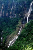 s
from Shillong. According to legend this lake was dug with the ends
of bows by members of 290 clans of U Sajiar Niangli, a rebel general
of Jaintia Raja, to commemorate the great exodus of the clans. It
is a historical lake and a beautiful spot for outing, boating and
picnic. s
from Shillong. According to legend this lake was dug with the ends
of bows by members of 290 clans of U Sajiar Niangli, a rebel general
of Jaintia Raja, to commemorate the great exodus of the clans. It
is a historical lake and a beautiful spot for outing, boating and
picnic.
Megalithic Remnants - Nartiang
65 Kms from Shillong, was the summer capital of the Jaintia
Kings, of Sutnga State. Huge monoliths, form the striking landmark
of the village, said to be erected by Mar Phalyngki, a Goliath of
yore. The Nartiang menhir measures 27 feet 6 inches in thickness.
The monoliths represent the megalithic culture of the Hynniewtrep
people. It is literally the Stonehenge of the Northeast of India.
A 500 years old temple of Durga is another attraction at Nartiang.
Syndai
An important village of Jaintia Hills which is famous for
a number of caves and caverns in the limestone-borne area, used
as hide-outs during war times between Jaintia Hills and foreign
intruders.
Syntu Ksiar
Syntu Ksiar, which means 'golden flower' is a vast pool of
calm water, where the river Myntdu which almost encircles Jowai,
appears to come to a sudden halt. At Syntu Ksiar, the Myntdu provides
a memorable scene of remarkable beauty as it seemingly disappears
for rest into thecalm of the mighty pool, and then, as if aroused
from a momentary invigorating slumber, it runs its ever vibrant
course, again.
Top
Tourist Places in Garo Hills
Garo Hills - Land of myths and
legends
Forming the Western part of the State the entire Garo Hills having
an area of approximately 8,000 sq. kms. Is densely forested and
hence one of the richest
spots in bio-diversity, one third (1/3) of which is the reserved
forest.
The Garos predominantly inhabiting the three district of the State
namely East Garo Hills, West Garo Hills and South Garo Hills are
basically superstitious, believed in spirits and have a rich traditional
tales of myth & legends. To the Garos everything that is interesting
and unnatural has to have the lore of some kind.
Tura, the headquarter of West Garo Hills, which was also the headquarter
of composite Garo Hills before two more district of East and South
Garo Hills were created, is 323 kms. From Shillong via Guwahati
named after a powerful Goddes Durama-Imbama, this Tura town is situated
at the foot of Tura peak. 5 kms of trek to the Tura at 1400 m the
peak offers some of the finest views of the hills against a back-drop
of low-lying plains and sweeping curve of the mighty Brahmaputra.
Garo Hills known for its abundance of wildlife should interest
naturalists and photographers to capture the variegated facets of
life of a unique range of flora and fauna. Two mountain ranges -
the Arabella range and the Tura range, pass through the Garo Hills,
forming the great Balpakram valley in between. The headquarters
town of Tura is 323 Kms via Guwahati, at an altitude of 657 Kms.
The highest point is Nokrek Peak with elevation of 1412 metres.
West Garo Hills
Nokrek biosphere
About 20 kms. via Asanagiri and sasatgiri but just 2 kms.
From Tura peak, teeming with wild life, Nokrek hill is the home
of a very rare species of citrus locally known as memang narang
- orange of the spirits. This memang narang is considered to be
the most primitive and progenitor of all other varieties of citrus
plants in the world with a view to preserve this rare species of
citrus indica the first gene sanctuary of the world has been established
here.
The highest point of the Garo Hills region of the State, Nokrek
Peak stands fourteen hundred and twelve metres above sea level.
A virgin canopy of thick, tall and lush green forests cover Nokrek
and its environs. The mother germo plasm of Citrus-indica have been
discovered by science researchers within Nokrek Range. This discovery
led to the establishment of the National Citrus Gene Sanctuary-cum-Biosphere
Reserve at Nokrek covering an area of forty seven square kilometres.
Nokrek can be reached from the Tura-Asanangre-Daribokgre Road.
A comfortable three and a half kilometre trek from Daribokgre village
leads a visitor to Nokrek Peak. Abundant wildlife including herds
of wild elephants, rare varieties of birds and pheasants, besides
rare orchids abound in the sanctuary.
Tura Peak
A majestic hill stands on the eastern flank of Tura, the largest
town in the Garo Hills region of the State. It peaks eight hundred
and seventy two metres above sea level over looking Tura. A tourist-bungalow,
an observatory and a Cinchona-plantation are located at Tura Peak
and its environs. A magnificent view of the lower Brahmaputra Valley
as well as the golden yellow plains of Bangladesh is available all
year round to viewers on Tura Peak.
Imilchang Dare
A waterfall of immense visual beauty is to be found close
to the Tura-Chokpot Road in West Garo Hills district. The stream
on which it is located, flows through a deep, narrow winding bed
of crevice rocks till it suddenly emerges on to a broad wide opening
and cascades in a thick, wide formation, over a broad chasm, creating
an electrifying waterfall of unique beauty. The deep, wide pool
at the bottom of the fall with its wide and expansive surroundings
make it an exciting swimming pool, full of fish of varied size and
colour, besides being an ideal picnic spot.
Rangapani :- 40 kms from Tura, near Mankachar on the Assam border
there still lies the earthly remains of the great general Mir-jumla
the Army General of great Moghul Emporer AurangZeb. Mir-jumla died
of malaria while returning from his excursion to the North East.
His tomb maintained by the local Muslim Association lies in this
village. Top
East Garo Hills
Williamnagar
Named after the 1st Chief Minister of Meghalaya this river
in town built on the curve of simang river is the Headquarter of
East Garo Hills. It is 313 kms from Shillong via Guwahati and is
76 kms from Tura.
Rongrenggiri
5 kms from Williamnagar is noted for being the last battle field
where the Garos bravely resisted the British.
Sisbibra
12 kms away from Williamnagar on the Tura Williamnagar road, a beautiful
place on the bank of Simsang river is of historical importance,
for it was here the legendary hero Togan Sangma along with his co-patriot
Gilsang Dalbot fell to the bullets of the British soldiers while
bravely resisting them. A memorial has been erected at the place
where the warriors fell down. District Council has constructed a
twin cottage near the memorial place where visitors can stay.
Adokgre
10 kms from Duphdara on the Assam Border Aadokgre was the first
camp in Garo Hills when the Garos coming from Tibet under the leadership
of Jappa-jalimpa arrived in to the promised land of Garo Hills.
It was from here they made their last recce and distributed the
land according to their Machongs (clan).
Naka-Chikong
15 kms from Duphdara, it is a big rock with deep hollows, in the
middle of Ilde river in Badaka village just 3 kms from Adokgre,
this big rock is mythologically believed to be swimming with fishes,
you can get tons of fishes any season of the year, but there is
one belief, if any one inadvertently touches the big rock under
whose hollow the fishes are. All fishes immediately disappear from
the river. The Hindus consider this a sacred place and regularly
come here for worship and picnic.
Napak
45 kms from Williamnagar there is a take formed by damming
of the upper tributary of a river during the great earth in 1897.
Napak was once the land of the spirits’s baby. The spirits
feeling insecure then migrated to Balpakram where they settled.
South Garo Hills
Comprising of the South East corner of Garo Hills South Garo Hills
District perhaps offers the best potentials for tourism development.
It was from this area great minds and great leaders were born.
Baghmara
Baghmara the head quarter of the District is a fast growing town
ship. It is situated on the banks of Simsang River on the International
Bangladesh border. Nearby just below the picturesque Disla hill
where the State Tourism Department had constructed a tourist bungalow
there is the Baghmara Wildlife sanctuary for the unique botanical
wonder of the State - an insectivorous pitcher plant known as memang
Koksi or the spirits basket.
Nengkong
14 kms north of Baghmara this place has 3 well known caves
Tetengkol Balwakol measuring 5, 33 kms in length is the 2nd longest
cave in the Indian Sub-continent. Two more caves-Dobakkol chibe
nala almost 2 kms long and another a little over 1 km long called
Bok-bak dobakkol are also in the vicinity of the area.
Siju Caves
The famous limestone caves of Siju are located near Naphak
Lake and the Simsang stalactites in these caves resemble those of
the Blue Grotto in the Isle of Capri. For more details, please see
the section on caves below.
30 kms north of Baghmara and 132 kms from Tura, Siju is famous
for Dabakkol or the bat cave with impressive stalagmites and stalactites.
It is the 3rd longest cave in the Indian sub-continent some of the
finest river passages to be found any where in the world. The magnificent
limestone rock formation inside especially named princess di’s
Chamber by the excavators will fill any visitor with awe.
Close by on the other side of simsang river Siju bird sanctuary
is the home for many rare and protected birds and other wildlife.
The Migratory Siberian duck also come here during winter months.
At the entrance to this bird sanctuary after a steep climb of nearly
1 km there is a stretch of fantastic rock formations that will take
your breath away.
Balpakram
A National Wildlife Park, located in South Garo Hills and
167 Kms from Tura. The literal meaning of Balpakram is the "land
of perpetual winds". There is a great precipice or deep gorge
in Balpakram and is popularly compared to the Grand Canyon of U.S.A.
It is believed that here, the spirits of the dead dwell temporarily
before embarking on the final journey. It is home to the rare Lesser
Panda, the Indian bison and the Stag like Serow. A variety of medicinal
herbs locally called "dikges" grow abundantly in Balpakram.
Top
Information on Tours & Travel excursion of Meghalaya - india
|


