|
Nasik
Forts And Caves
[ Teertharaj Gajapantha | Pandav Caves | Mahuli | Ajoba | Ratangad ]
Teertharaj Gajapantha - Chamber Caves
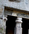
Nasik City and the surrounding area is famous for many temples, pilgrimage places etc. One of the sacred places for Jain Religion is Teerthraj Gajpantha , which is at Mhasrul, 16 kms from Nasik Road Railway station and 5 kms from Nasik City. The famous CHAMBER CAVES are a part of this place. It is situated on the top of a small hill which is only 400 ft tall. The staircase, built in black stone leads to the temple and offers a panoramic view. Although the nearby landscape is quite barren, some plantation has been recently done. This is a very serene place, conducive for meditation. Gajapantha Teerth includes a caravanserai, a small hut the foot of the hill and a temple at the top of the Gajadhwaja Hillock. As per the ancient holy book "Shantinath Purana" Mysore's Chamaraj King installed these statues (600 B.C.) in the temple top the hill. Thus the caves got the name "Chamer Caves" or "Chambhar Caves" in the regional language.
Top
Pandav Caves(Pandav Lani)
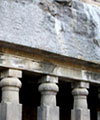
Pandav Lani is situated at a distance of 9km from Central Bus Stand.These are three mountain peaks of Anjinagiri mountain ranges.These caves were built by Jain Kings and are 2000 years old.The engravings inside the gumpha are believedto be of Pandavas of 17th Century and thus these caves are named as "Pandav Caves".
Top
Mahuli Area
This area comprises the mountains around Mahuli village, which is situated 5km from Asangaon. Asangaon is accessed by local train from Mumbai and is on the Kalyan-Kasara line. It is 85km from Mumbai, and it takes two hours and fifteen minutes to reach Asangaon by a slow local train.
Mahuli fort
This is a popular hiking place since it is easily accessible. It was the site of many fierce battles in the 18th century.
Top
Ajoba
This is one of the most impressive looking mountains in this region. The main reason being that it kind of juts out of the main range of Sahyadris. The views from the top of this mountain are one of the best in the Sahyadris. On the north one gets good view of Kulang, Madangad, Alang and Kalsubai and on the west we get view of Ratangad, Kathra and Ghanchakkar and on the south we get views of Harishchandragad and Napta. The trek is a two day trek from Mumbai, and somewhat demanding.
If one takes the first local from Mumbai is it easily possible to get to the top of the mountain by afternoon 2-3 pm. The travel in this case is to first get off from the train at Asangaon and via Shahpur reach Dolkamp as mentioned in the section on the Chhonda-Ghatghar pass.
Chhonda-Ghatghar Pass
This is a gentle pass connecting Chhonda in the Konkan to Ghatghar (~700mtrs) village on the Bhandardhara plateau. The standard way to reach is first take a train from Mumbai to Asangaon. From there one takes an auto or a bus to Shahpur which is actually a town. At Shahpur there are not too many buses going to Chhonda so the standard option is to take a bus to a place called Dolkamp (25 km). From here there are lots of jeeps going to Sakurdi and Chhonda. Near Sakurdi village there is a bifurcation on the road,with one heading towards the Ghondawadi village and another towards Chhonda. Before this route was constructed there was a trail which climbed one of the steep cuts coming from the top. There are in all about four of these cuts. Two of them are actually very close to the standard path. All of these are apparently climbable, and atleast two of these are quite easy. Infact the leftmost one used to be the standard route to Ghatghar till atleast 1996.
Alang
The route for this mountain is from Ghatghar. So first take the Chhonda-Ghatghar pass and reach Ghatghar. One have to take the path of the woodcutters path.
Kulang
The Kulang and the Chhota Kulang form one edge of the main range of the Sahyadris in the Igatpuri region. The Harish kapadia's book describes a route starting from Igatpuri. There are ways of avoiding to go to Igatpuri for this trek.
Top
Ratangad
This interesting fort is one of the most common treks in the southern Igatpuri region. The standard route to climb this fort is from Ratanwadi which is the base village. This beautiful village unfortunately is reached by a very long travel from Mumbai. The standard method is to reach Igatpuri or Ghoti from Mumbai and take a bus to Bhandardhara. There is a bus in the morning from Kasara, which goes all the way to Bhandardhara. On the bus one gets a good views of the mountains all round and most noticeable one is the Kalsubai (1640 mtrs) which is the highest mountain in Sahyadris. The Patta fort and the Avandh pinnacle are also visible.
Top
Information of Forts and Caves in Nasik city of Maharashtra
- India
|