| Encyclopedia of Tours and Travel to Maharashtra, featuring information on Fairs & Festivals, Wildlife, Excursion, Adventure and Weather of Maharashtra. |
 |
 |
 |
 |
 |
 |
 |
||
|
Ahmednagar
Visit Places Shirdi is a town in the Ahmednagar district of the state Maharashtra in India. It is located at 19° 45' N, 74° 25' E, 83 km north of the city of Ahmednagar and at a distance of 15 km from the town Kopargaon. It has acquired fame as a place of pilgrimage because the Shirdi Sai Baba lived there and is buried there. Some Muslims, Hindus and Sikhs consider him a saint with miraculous powers. He was from pathri dist parbhani and his guru was Babasaheb Maharaj who was from Selu near Parbhani. Sugar cane is cultivated in its surroundings. Meherabad Meherabad is a popular place of pilgrimage for both eastern and western disciples of Meher Baba with reported numbers of around 30,000 pilgrims at Amartithi (the celebration of his passing, January 31). The Pilgrim Center located there is open to the public. There is also a free dispensary and school. In later years Meher Baba established a separate residence named Meherazad located near Pimplagaon, which is on the other side of Ahmedagar. Meherazad was the last residence of Meher Baba and is today a place of spiritual pilgrimage outside Pimplagaon village, approximately nine miles from Ahmednagar, India. Meherazad was established in about 1948 or slightly earlier. The complex features buildings, gardens and vehicles pertaining mostly to Baba's later phases. Of special interest is Baba's Room. Seclusion Hill, where Baba did much work, rises behind Meherazad. It is open to visitors on Tuesdays, Thursdays, and Saturdays from 11:00 am to 3:00 p.m., and Sundays from 10:45 am to 12:30 p.m. Some of Meher Baba's surviving mandali still resides there. Ralegan Siddhi
Harishchandragad is a hill fort in the Ahmednagar region of India. Its history is linked with that of Malshej Ghat, and it has played a major role in guarding the surrounding region.
To the east of the temple is a well-built lake is called "Saptatirtha". On its bank are temple-like constructions in which there are idols of Lord Vishnu. Recently these idols have been shifted in the caves near the temple of Harishchandreshwar. These days many trekkers have been responsible for the sad plight of this beautiful place, as they throw plastic wastes and other things in the pond. 7 years back the water was potable, and now it isn't suitable even to swim. Going rightwards of Harishchandreshwar temple, we come across a huge cave. This is the cave of Kedareshwar, in which there is a big Shivlinga, which is totally surrounded by water. The total height from its base is five feet, and the water is waist-deep. It is quite difficult to reach the Shivlinga, as the water is ice-cold. There are sculptures carved out here. In monsoon it is not possible to reach this cave, as a huge stream flows across the way.
The most interesting point on this fort is this cliff, which has always fascinated many people from many years. The cliff faces west and looks down upon the Konkan. From here, one can have a breathtaking view of the surrounding region and the setting sun. This cliff is not just vertical, it is an overhang, almost like a cobra's hood. It has been climbed twice so far. The first climb was in 1985 by a group from IIT Bombay (V. V. `Badya' Limaye, Jayant Kulkarni, Girish Sant, Anand Pai, and others). The second climb was in 1997 by a team from the Pinnacle group. A youth from Pune jumped to his death from here; a monument is built here in his memory. It is said that a rainbow as a circle can sometimes be seen from here. This is the topmost point on the fort. Leopards are seen in the forests beyond this peak. From here we can have a glimpse of the whole range of Naneghat and the forts near Murbad.
These caves are situated all over the fort. Many of these are situated at the foot of Taramati peak & are the place of accommodation. A few are near the temple, whereas some are near the citadel and some far away in the forests. A natural cave is on the northwestern side of the fort, to the right of Kokan Kada. It is about 30 feet deep. The folks must know many such caves. Many of these may be remaining undiscovered.
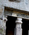
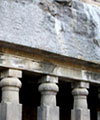
Nageshwar temple near Khireshwar This is a great antique construction, and diverse artistic works are seen on this. On the ceiling of the temple are beautiful carvings. There are caves near the temple. This temple is marvelous example of the fine art of carving sculptures out of stones that prevailed in ancient India. It is about 16m high from its base. Around this temple there a few caves & ancient water tanks. The river Mangal Ganga is said to originate from one of the tanks located close to the temple. The top of the temple resembles construction with the north-Indian temples. A similar temple is situated in Buddha-Gaya. Here we can see many tombs, in which a typical construction is seen. These are built by well-finished arranging stones one on top of the other. There are three main caves near the temple. The cisterns near the temple provide drinking water. A short distance away, another temple called Kashitirtha is located. The fascinating thing about this temple is that it has been carved out from a single huge rock. There are entrances from all four sides. On the main entrance there are sculptures of faces. These are faces of guards of the temple. On the left side of the entrance is a Devnagri inscription, which is about saint Changdev. Ways to Reach Harishchandragad lies where the boundaries of Thane, Pune & Ahmednagar districts converge. From Thane District: One has to board the bus for Nagar from Kalyan & alight at 'Khubi Phata'. From there we reach the village of Khireshwar by bus or private vehicle. This village is at 4km from the foothills of the fort. Way from Khireshwar: The way beside the caves, where water tanks are seen, proceeds further to Junnar Darwaaja (Entrance from Junnar). From here, the route goes straight to Tolar Khind. Walking a few minutes from Tolar Khind, we come across a rock-patch on which railings are fixed. After ascending the railings, we come to the plateau region on which less dense forests are seen. From here, we have to cross 7 hills & after a walk of 2-3 hours, we reach the temple of Harishchandreshwar, the temple of Lord Shiva. Note: On this way, many arrows help in indicating the way. Way from Belpada: The third way is specially meant for hikers, which is via Sadhleghat. One should board the bus for Malshej Ghat & go to the village of Belpada. From here, the route goes through Sadhleghat. Here one has to climb a straight rock patch on which grips are provided. The temple is situated at a height of about 1km from Belpada. The total distance is about 19km. From Ahmednagar District: One has to board the bus for Nasik or Mumbai & alight at Ghoti village. From Ghoti, we have to board another bus to Sangamner via Malegaon & alight at Rajur village. From here, 2 ways diverge to the fort. 1) From Rajur, one has to board the bus or a private vehicle to the village of Pachanai. From here, the way is straight to the topmost point. Pedgaon is a small village in the Parbhani district of India, at 18.5166667 latitude and 74.7 longitude.
|
||||||||||
|
||||||||||
|
||||||||||
|---|---|---|---|---|---|---|---|---|---|---|