| Encyclopedia of Tours and Travel to Maharashtra, featuring information on Fairs & Festivals, Wildlife, Excursion, Adventure and Weather of Maharashtra. |
 |
 |
 |
 |
 |
 |
 |
||
|
Mumbai
History In 1534, the Portuguese appropriated the islands from Bahadur Shah of Gujarat. They were transferred to Charles II of England in 1661, as dowry for Catherine de Braganza. These islands were in turn leased to the British East India Company in 1668 for a sum of £10 per annum. The company found the deep harbour on the East Coast of the islands to be ideal for setting up their first port in the sub-continent. The population quickly rose from 10,000 in 1661, to 60,000 in 1675; in 1687, the British East India Company transferred its headquarters from Surat to Bombay. From 1817 onwards, the city was reshaped with large civil engineering projects aimed at merging all the islands in the archipelago into a single amalgamated mass. This project, known as the Hornby Vellard, was completed by 1845, and resulted in the total area swelling to 438 km². In 1853, India's first passenger railway line was established, connecting Bombay to the town of Thane. During the American Civil War (1861-1865), the city became the world's chief cotton trading market, resulting in a boom in the economy and subsequently enhancing the city's stature. The opening of the Suez Canal in 1869 transformed Bombay into one of the largest seaports on the Arabian Sea.
Over the next thirty years, the city grew into a major urban centre, spurred by an improvement in infrastructure and the construction of many of the city's institutions. The population of the city swelled to one million by 1906, making it the second largest in India after Calcutta. It later became a major base for the Indian independence movement, with the Quit India Movement called by Mahatma Gandhi in 1942 being its most rubric event. After independence, the city expanded to its present limits by incorporating parts of Salsette Island. It became the capital of the new linguistic state of Maharashtra in 1960. The late 1970s witnessed a construction boom and a significant inflow of migrants, which saw Bombay overtake Calcutta as India's most populous city. The city's secular fabric was torn in 1992, after large-scale sectarian violence caused extensive loss of life and property. A few months later, on March 12, simultaneous bombings at several city landmarks by the Mumbai underworld killed around three hundred people. In 1995, the city was renamed Mumbai, by the right wing Shiv Sena party government of Maharashtra, in keeping with their policy of renaming colonial institutions after historic local appellations. Geography Three lakes are located within the metropolitan limits - the Tulsi Lake, Vihar Lake and Powai Lake. The first two are located within the Borivali National Park, and supply part of the city's drinking water. Mumbai also has three small rivers within the city limits originating in the National Park. The coastline of the city is indented with numerous creeks and bays. The eastern seaboard of Salsette Island is covered with large mangrove swamps, rich in bio diversity. Soil cover in the city region is predominantly sandy due to its proximity to the sea. In the suburbs, the soil cover is largely alluvial and loamy. The underlying rock of the region is composed of black Deccan basalt flows, and their acid and basic variants dating back to the late Cretaceous and early Eocene eras. Mumbai sits on a seismically active zone[3] owing to the presence of three fault lines in the vicinity. The area is classified as a Zone III region, which means an earthquake of up to magnitude 6.5 on the Richter scale may be expected. Mumbai is classified as a metropolis of India, under the jurisdiction of the Brihan Mumbai Municipal Corporation. It consists of two distinct regions - the city and the suburbs, which also form two separate districts of Maharashtra. The city region is also commonly referred to as the Island City. Climate Moderate levels of humidity and warm to cool weather characterize the dry season, between November and February. Cold northerly winds are responsible for a mild chill during January and February. Annual temperatures range from a high of 38 °C (100 °F) to a low of 11 °C (52 °F). The record high is 43 °C (108 °F) and record low is 7.4 °C (45 °F) on 1962-01-22.
|
||||||||||
|
||||||||||
|
||||||||||
|---|---|---|---|---|---|---|---|---|---|---|
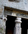
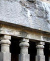
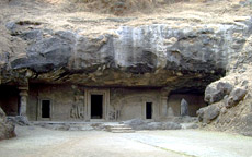 Kalbadevi Road - Glimpse of Mumbai around 1890.Present-day Mumbai was originally an archipelago of seven islands. Artifacts found near Kandivali, in northern Mumbai indicate that these islands had been inhabited since the Stone Age. Documented evidence of human habitation dates back to 250 BC, when it was known as Heptanesia (Ptolemy) (Ancient Greek: A Cluster of Seven Islands). In the 3rd century BCE, the islands formed part of the Maurya Empire, ruled by the Buddhist emperor, Asoka. The Hindu rulers of the Silhara Dynasty later governed the islands until 1343, when the kingdom of Gujarat annexed them. Some of the oldest edifices of the archipelago - the Elephanta Caves and the Walkeshwar temple complex date from this era.