|
Buldhana
 Buldhana District has an area of 9,680 km² and is located in Amravati Division of Maharashtra, located in central India. It is around 500 km from the state capital, Mumbai. Buldhana District has an area of 9,680 km² and is located in Amravati Division of Maharashtra, located in central India. It is around 500 km from the state capital, Mumbai.
The world largest hypervelocity meteorite impact crater in basaltic rock, the Lonar crater, is located in Buldhana district.
The district is bounded on the north by Madhya Pradesh state, to the east by Akola and Washim districts, to the south by Parbhani and Jalna districts, and to the west by Jalna and Jalgaon districts.
The district is the western most district of Vidarbha.
Origin of name
It is also spelled as Buldana earlier.
History
It is believed that Buldhana, along with the rest of the erstwhile Berar province, was part of the legendary kingdom of Vidarbha mentioned in the Mahabharata. Berar also formed part of the Mauryan Empire during the reign of Asoka (272 to 231 BCE). Berar later came under the rule of the Satavahana dynasty (2nd century BCE-2nd century CE), the Vakataka dynasty (3rd to 6th centuries), the Chalukya dynasty (6th to 8th centuries), the Rashtrakuta dynasty (8th to 10th centuries), the Chalukyas again (10th to 12th centuries), and finally the Yadava dynasty of Devagiri (late 12th to early 14th centuries. A period of Muslim rule began when Ala ud din Khilji, Sultan of Delhi, conquered the region in the early 14th century. The region was part of the Bahmani Sultanate, which broke away from the Delhi Sultanate in the mid-14th century. The Bahmani Sultanate broke up into smaller sultanates at the end of the 15th century, and in 1572 Berar became part of the Nizam Shahi sultanate, based at Ahmednagar. The Nizam Shahis ceded Berar to the Mughal Empire in 1595. As Mughal rule started to unravel at the start of the 18th century, Asaf Jah I, Nizam of Hyderabad siezed the southern provinces of the empire (including Berar) in 1724, forming an independent state.
Mother of Chhatrapati Shivaji, Veer Mata Jijabai was born at Sindkhedraja, at the Palace of Lakhuji Jadhav.
In 1853, the district together with the rest of Berar came under the administration of the British East India Company. Berar was divided into East and West Berar with Buldhana district being included in West Berar. In 1903, Berar was leased by the Nizam of Hyderabad to the British Government of India.
Buldhana district forms the west part of Amravati division now.
Top
Geography
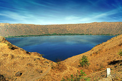 The world heritage site of Lonar crater is located in Buldhana district. The world heritage site of Lonar crater is located in Buldhana district.- The d boundary latitude are: 19.51° to 21.17° N and longitude are: 75.57° to 76.59° E
- The climate is tropical and people mostly use cotton clothes.
- The district lies in the Tapti River and Godavari River basins. Purna River is tributary of Tapti River while Penganga River and Kadakpurna River are tributaries of Godavari River.
Here are some of the rivers in Buldhana, with their tributaries
- Purna River
- Vaan River
- Mann River
- Utawali River
- Nipani River
- Mas River
- Bordi River
- Dynanganga River
- Vishwaganga River
- Nalganga River
- Penganga River
- Kadakpurna River
The district of Buldhana comprise of thirteen talukas namely Malkapur, Motala, Buldhana, Chikhali, Mehkar, Sindkhedraja, Lonar, Deoulgaonraja, Khamgaon, Nandura, Shegaon, Sangrampur, and Jalgaon-Jamod.
Buldhana district is located in the central portion of the state of Maharashtra. Akola, Jalgaon, Jalna, Parbhani are the adjoining districts to the east, west & south respectively. Nemad district of the M.P. is to the north & lies between 19°51' to 21°17' North latitude and 75°57' to 76°49' East Longitude.
Buldhana (Buldana) is a city in the state of Maharashtra, India. It is the headquarters of Buldhana District. It is located on the top of a mountain in Ajanta ranges, in central India and is about 900 m above sea level.
Buldana (Buldhana) is located in the state of Maharashtra in India.
Taluka: Buldhana
District: Buldhana
STD Code: 07262 (India country code: 91)
Nearest Railway Station: Malkapur (45 Km.)
Languages: Marathi, Hindi
Major Crop: Cotton
Top
 Places of interest Places of interest
- Lonar, place of Lonar Crater, Lonar Lake and Lonar Sanctuary; around 90 km to the south.
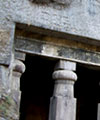
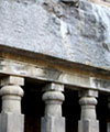
- Ajanta caves, 50 km away from the city.
- Sindkhedraja, birth place of Veer Mata Jijabai, mother of Chhatrapati Shivaji and Palace of Lakhuji Jadhav, around 100 km
- Shegaon, also known as Pandharpur of Vidarbha, home to the Sant Gajanan Maharaj, around 90 km
- Mehkar, the famous Balaji Temple.
- Deoulgaonraja, the famous Balaji Temple.
- Chikali, the Durgah of Sailani Baba
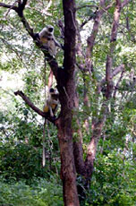
- Dnyanganga Sanctuary
- Ambabarva Sanctuary
- Nandura, for the world's biggest Hanuman idol.
Top
General Information & Accomdation info on Buldhana city of Maharashtra
- India
|